 |
Currently marked routes |
 |
Routes eliminated or renumbered 1960-present |
 |
Routes eliminated or renumbered 1950-1960 |
 |
Routes eliminated or renumbered 1930-1950 |
 |
Routes for which there is conflicting information about their present or past existence. |
| 71 | Routes for which no record has been found so far of this number being assigned. (Post-1927 only). |

North terminus: U.S. 70 (N. Main St.) in Las Cruces
Length: 4 mi.
County: Doņa Ana
History: Solano Avenue from University Avenue north to Main Street has been a minor north-south arterial on the east side of Las Cruces for many years. It was probably a state highway for a few years from the 1970s to the 1980s, possibly to fund some improvements. This route would have been removed from the state highway system by 1988 because the route number was reused that year (see next entry).
Improvements: 2-4 lane city street
Comments: I noted this on a couple of Gousha El Paso vicinity maps from the 1970s and early 1980s.

East terminus: NM-14 N of Golden
Length: 11 mi.
County: Sandoval, Santa Fe
History: One of the numerous segments of NM-22 renumbered in 1988. This route was removed from the highway system before the mid-1990s.
Improvements: Gravel road
Comments: The Sandoval county portion is County road 52A.
302

North terminus: NM-314 (Bridge Blvd.) in Albuquerque
Length: 6 miles
County: Bernalillo
History: When NM-47 was re-routed in 1988 to continue up Broadway into Albuquerque, this route was created along Second Street SW. Previously, NM-47 had jogged west from Broadway at Properity Avenue and then followed Second Street into downtown. The new NM-303 did not include Prosperity Avenue, but rather went south along Second Street to NM-47. It appears to have been removed from the state highway system around 2000.
Improvements: Two-lane paved
Comments:
North terminus: NM-47 at Rio Communities
Length: 23.284 miles
County: Socorro, Valencia
History: Originally the southern portion of NM-47, renumbered in 1988 when NM-47 was routed southeast over former NM-6.
Improvements: Paved, two lane
Comments:

Previously --- NM-96 at Regina (1960s-1988)
North terminus: NM-595 S of Lindrith
Length: 0.500 miles
County: Rio Arriba
History: Originally the southern end of NM-95, became NM-305 when the south end of the former route was realigned more northerly in the 1960s (date unclear). The portion in Sandoval County was removed from the state highway system in 1988.
Improvements: Paved, two lane
Comments: This very short route was only found because of its listing on the state highway log.

East terminus: NM-333 at Sedillo
Length: 10 miles
County: Bernalillo
History: Year of establishment not known. In the mid-1970s, this was shown as an extension of NM-44, and it was likely changed in 1988. Probably removed from highway system in the 1990s.
Improvements: Paved, two lane
Comments: I first noticed this in a map in the Qwest phone directory in Albuquerque. However, that directory indicated the extent of a few state highways that have been borne out with further review, and I found this on a 1988 official NM state map.

East terminus: U.S. 85 S of Albuquerque
Length: 3 miles
County: Bernalillo
History: Created early 1960s (?), eliminated by late 1960s when NM-500 (Rio Bravo Blvd.) extended west to NM-45 (Coors Road) just south of this road.
Improvements: Paved, two lane
Comments: Ran along Barcelona Road. Only shows on the Albuquerque inset of the 1964 Rand McNally atlas. No other maps show enough south of Albuquerque to be totally sure of the history of this road. In any event, once NM-500 was extended west, this road would have been redundant.
308

East terminus: NM-47 at Rio Communities
Length: 2.432 mi.
County: Valencia
History: Originally part of NM-6 heading east from Belen, renumbered in 1988.
Improvements: 2-lane, paved road
Comments: Reinken Avenue in Belen
310

East terminus: U.S. 60-84 W of Gallagher
Previously --- NM-277 N of Richvale (1950s-80s)
Length: 22.869 mi.
County: Curry
History: Established mid-1950s on the original northwest segment of NM-277 when that route was redirected north to NM-89. When that northern extension of NM-277 was eliminated by the late 1980s, this route took over the segment south to U.S. 60-84.
Improvements: Two-lane, paved
Comments:

East terminus: NM-268
Length: 8.112 mi.
County: Quay
History: Established late 1950s. Unchanged since that time.
Improvements: Paved, two lane road.:

North terminus: FR 2530 (I-25 frontage road) N of Algodones
Previously --- NM-314 S of downtown Albuquerque (with a gap between Lomas Blvd. and Central Avenue)
Length: 17.091 mi.
County: Bernalillo, Sandoval
| History: Replaced
U.S. 85 along 4th St. NE in Albuquerque
north to Algodones in 1988. The portion along 4th St. was removed
from the state highway system around 2000, and NM-313 was terminated
at NM-556 (Roy Road, which is the westward extension of Tramway
Blvd.). The short portion between this junction and the intersection
of 2nd and 4th Streets is now marked NM-556.
This was part of the original routing of U.S. 66 (along with 85) north of Albuquerque, until it was re-routed in 1937 east-west through Albuquerque. |
 |
Improvements: Two and four lane, paved
Comments: This route change was field checked. Signage along 4th Street north of Albuquerque is definitely not NMDOT signage, but rather is probably Bernalillo County signage.

Previously --- I-25 S of Belen (1988-late 90s)
North terminus: I-25 (exit 213) S of Albuquerque
Previously --- I-25 (exit 223) in Albuquerque (1988-1995)
Possible former independent segment:
South terminus: I-40 in downtown Albuquerque
North terminus: NM-47 N of downtown Albuquerque
Length: 18.523 mi.
County: Valencia, Bernalillo
| History: Replaced
U.S. 85 between Belen and Albuquerque in
1988. In the 1990s, the segment through downtown Belen was replaced
by Business Loop I-25. The Benchmark Atlas shows a separate segment
north of downtown Albuquerque along 2nd Street NW between I-40 and
Candelaria (where NM-47 jogs over from Broadway and turns north
along 2nd Street). This latter segment was originally part of
Alternate U.S. 85, and was likely marked NM-47 from the late 1970s
until 1988. The route is shown on the 2003 New Mexico highway map as
terminating at I-25 south of Albuquerque.
Part of this route was the original routing of U.S. 66 (along with 85) between Albuquerque and Los Lunas (where it turned west to follow present-day NM-6), until U.S. 66 was re-routed in 1937, east-west through Albuquerque. |
 |
Improvements: Two and four lane, paved
Comments: Entered Albuquerque from the south along Isleta Boulevard.

East terminus: I-25 (exit 248) at Algodones
Length: 0.479 mi
County: Sandoval
History: Probably established around 1988, too short to show on most maps.
Comment:
316

East terminus: NM-45 at Isleta
Length: 1.020 mi
County: Bernalillo
History: Probably established around 1988, possibly a few years earlier.
Comment:

East terminus: U.S. 60-70-84 E of Clovis
Length: 1.5 mi
County: Curry
History: Year of establishment not known, probably prior to 1988 because of the number. Probably removed from state highway system before 2000.
Comment: The east half of the loop (the west half was NM-270) around the south side of Clovis.

East terminus: NM-28 near the Texas State Line
Length: 2 mi
County: Doņa Ana
History: Year of establishment not known, but this existed in the early 1980s. If it is related to NM-320, it could be much earlier. Probably removed from state highway system by 2000 when it was consolidated with NM-273.
Comment:

East terminus: I-25 (exit 9)
Previously --- NM-28 at Doņa Ana (1950s-60s)
Length: 2.000 mi
County: Doņa Ana
History: Shows on maps from the mid-1950s, terminated at the town of Doņa Ana until construction of I-25 in the late 1960s.
Comment: Thorpe Road

East terminus: Texas State Line (TX FM-54)
Length: 4.606 mi
County: Roosevelt
History: Established around 1970.
Comment:

East terminus: NM-8 at Monument
Length: 3.152 mi
County: Lea
History: Date of establishment unknown. Appears to have been created to serve a refinery, much like NM-175 down the road.
Comment:
323
324
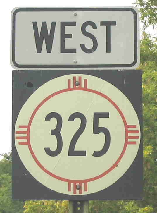
Photo taken west of junction NM-456 at Folsom. This is an older (pre-1988) style of route marker. Virtually all the signs from the pre-1988 wooden sign era look like this.
East terminus: U.S. 64-87 at Des Moines
Previously --- Oklahoma State Line (OK-325) at Kenton
Length: 16.669 mi.
County: Union
History: Established 1949 when U.S. 64 was rerouted along U.S. 87 to Clayton and a newly constructed route northeast into Oklahoma. In 1988, the segment northeast of Folsom was renumbered NM-456 and NM-325 assumed the former easternmost segment of NM-72.
Improvements: Two-lane paved road
Comments: This is the first route to have been assigned a route number over 300. I have a 1948 atlas that shows U.S. 64 on its original alignment, and there are only two routes in New Mexico numbered in the 200s. The only reason I can see for having rerouted NM-325 in 1988 was that at Folsom, it formerly turned left onto what is now NM-456. The "no overlay" rule would have cut off NM-72 at the junction just north of here, but it would have required changing less roadway if they had assigned the new number to the east segment of 72 and left 325 as it was. I would undo this renumbering, restore 325 along 456 (which will match the Oklahoma number), and either give the segment east of Folsom to U.S. 64-87 a new number or allow a short overlay with 72 and call that 72 like it used to be.
326

East terminus: U.S. 84-85-285 (Old Pecos Trail) in Santa Fe
Length: 3 mi.
County: Santa Fe
History: Designated 1950s, removed from state highway system 1958.
Improvements: Urban street (probably two lane)
Comments: The original "truck bypass" around the plaza, before St. Michael Drive was constructed. This route was Don Gaspar and Galisteo Streets near Santa Fe Plaza.

East terminus: NM-47 at MP 40.57
Length: 0.560 mi.
County: Bernalillo
History: Designated 1995
Improvements: Two lane paved
Comments: Isleta Lake Road
328

Length: 1.881 mi.
County: San Miguel
History: Likely designated prior to 1988 (because of its number).
Improvements: Two and four lane paved
Comments: Runs along New Mexico and Mills Avenues in Las Vegas, connecting the old Spanish town (West Las Vegas) and the "newer" East Las Vegas that grew up along the A.T. & S.F Railroad. The Mills Avenue portion is shown on the state highway log as being turned back to the city of Las Vegas.

North terminus: NM-267 near Floyd
Length: 20.363 mi.
County: Roosevelt
History: Established early 1950s. Route unchanged since that time.
Improvements: Paved two lane
Comments:

North terminus: NM-418 W of Deming
Length: 11 mi.
County: Luna
History: Established late 1950s (originally extended only about 3 miles south of then-U.S. 80). By 1960s it extended further south. Probably removed from state highway system by late 1980s.
Improvements: Paved two lane
Comments: Now Luna County C-91

East terminus: NM-11 at Sunshine
Length: 4 mi.
County: Luna
History: Established mid-1960s, connecting NM-331 with NM-11. Removed from state highway system by early 2000s.
Improvements: Paved two lane
Comments:

Length: 27.715 mi.
County: Bernalillo, Santa Fe, Torrance
| History: | Established on the route of old U.S. 66
by the mid-1980s when that route was decommissioned.
They are never celebrated on brown "Historic Route" signs, but originally this was part of U.S. 470 and then U.S. 366, until the original route of U.S. 66 was changed from the Santa Fe routing to a direct east-west routing between Santa Rosa and east of Grants. |
 |
Improvements: Paved two lane
Comments: Follows I-40 very closely - almost a frontage road along most of its length.

(a) West terminus:
U.S. 66 at Bluewater
East terminus: NM-53 N of
Milan
Length: 6 mi.
History: This westernmost segment was established in the mid-1950s, and appears to have always been separate of the other two segments (which were joined for a time). However, it could have been connected to Segment (b) by being overlaid on NM-53. It appears to have disappeared by 1980. Its route does not show on a current detailed atlas.
(b) West
terminus: NM-53 at San Mateo
East terminus: E of San Mateo
Length: In the late 1960s, extended 9 miles east of San Mateo. Originally, it was connected to segment (c), total length of (b) and (c) together of about 48 miles.
History: Apparently created early 1950s, continuous with segment (c). By 1960, the two segments were separated with this segment ending east of San Mateo at the Cibola National Forest boundary. The connecting segment was probably deemed impassible. Appears to have been removed from state highway system by around 1970. Roads east of San Mateo to Cibola NF boundary are shown on atlas as NFS routes.
(c) West terminus: NM-53
at San Mateo
East terminus: NM-279 at
Marquez (when combined with segment (b))
After 1960, extended from 14
miles north of Encinal to Encinal. Connection to Marquez appears to have
been closed.
History: With segment (b), created early 1950s. By 1960, separated from segment (b) and east end was also severed. Eliminated by 1980, roads do not show on current detailed atlas.
Comments: At some point I will scan and post a map to show the layout of this route.
335
336

East terminus: Texas State Line
Length: 16 mi.
County: Lea
History: Established early 1950s. Around 1963, U.S. 82 was extended into New Mexico over this route.
Improvements: Paved two lane
Comments:

North terminus: NM-333 near I-40 exit 175 at Tijeras
Length: 29.685 mi.
County: Torrance, Bernalillo
History: Part of NM-14 (and earlier, NM-10), which was broken up in the 1988 renumbering to eliminate concurrent segments.
Improvements: Paved two lane
Comments: Folks thereabouts still call this "South 14." It would have made more sense to maintain NM-14 on this segment to keep the continuous route, and to have renumbered one of the pieces of NM-333 instead. I would restore the continuity of NM-14 (allow a short overlay with 333).

North terminus: I-10 (exit 11) W of Lordsburg
Length: 24.440 mi.
County: Hidalgo
History: Established early 1950s along its current extent. By the late 1950s, it had been extended south along the most southerly segment of NM-180 to NM-79 E of Cloverdale when the segment of NM-180 between Animas and Lordsburg was removed from the state highway system. This latter segment was removed from the state highway system, probably in 1988.
Improvements: Paved two lane
Comments: A commenter indicated that NM-338 is still marked for a short distance south of Animas, and I drove through there in 2005 and observed that junction. The state highway log description bears this out. This would represent a departure from the "no overlay" rule, since the segments of NM-338 north and south of Animas were connected by a short common section with NM-9.

North terminus: NM-2 at Dexter
Length: 5.860 mi.
County: Chaves
History: Too short to determine when it was first marked, but the road is shown on maps from the late 1960s. Probably established around the time of NM-558, early 1970s.
Improvements: Paved two lane
Comments:

North terminus: NM-2 N of Dexter
Length: 7.067 mi.
County: Chaves
History: Too short to determine when it was first marked. The road is only shown on the Benchmark Atlas and the 2003 New Mexico highway map. Because of the consecutive numbers with intersecting NM-339, I am guessing it was established the same time.
Improvements: Paved two lane
Comments: Runs west from NM-2, crosses NM-339, then turns north to intersect NM-2 which by this point runs to the NNW.

See --- it had to have existed at one time! Sign looks like the style used from the late 1990s on, unlike the 1988 signs with small 3-digit numbers. Photo by Bobby Magill, 2005.
East terminus: Servilleta (?)
Length: ? mi.
County: Rio Arriba
History: Bobby Magill reported seeing signs marking this route in the field. This report led me to look on-line, and Mapquest shows a "State Road 341" leaving NM-519 in the area Bobby mentioned, though the length of this road isn't clear. He has a photo, so the road existed at least at one time. Not shown on any printed maps nor the current state route log or milepost map. I therefore conclude it isn't currently a state route.
Improvements: Not known
Comments: The endpoint isn't clear. Bobby indicated it went to Servilleta, which is not shown on any of my maps. When I did a search on Mapquest or Google, "Servilleta" is shown as a settlement east of U.S. 285, generally northeast of the area indicated for this road above. The USGS topographic map shows a "Servilleta Tank" in the same area as Mapquest indicated. It is likely that the identity of these small villages is not clear or even unique, though it would be unusual to find two villages in the same county with the same name. Also, if it is a newer route than 1988, I am surprised a 3xx instead of a 5xx designation would be used unless the state adopted the identity of a county or NFS road. Obviously it was a state route for at least a time since there is signage.

East terminus: I-25 (Exit 3) in Las Cruces
Length: 4 mi.
County: Doņa Ana
History: Probably established mid-1960s, when I-25 was opened from U.S. 70 south to this exit. Appears to have been removed from state highway system, early 2000s.
Improvements: Paved two and four-lane
Comments: Never posted with this designation. Ran on Amador Avenue, then on the Amador-Lohman Avenues one-way couplets, and finally on Lohman Avenue to I-25.
343

Length: 17.372 mi.
County: Santa Fe
History: Established early 1950s.
Improvements: Paved two and four-lane
Comments:

North terminus: St. Josephs Avenue in Albuquerque
National Highway System: NO, regardless of what I may have said here in the past (see NM-347)
Length: 3.645 mi.
County: Bernalillo
History: Established 1990s. Removed from highway system in October 2010, as part of a roadway swap with the city of Albuquerque. The city took jurisdiction over this road in exchange for NMDOT taking jurisdiction over the southern part of Coors Blvd. between Old Coors and St. Josephs.
Improvements: Four-lane urban boulevard
Comments: Unser Boulevard (named for famed race driver and Albuquerque native Al Unser) is evidently intended to be an arterial that runs from the west side of Albuquerque north through Rio Rancho. It is probably not envisioned as more than an urban boulevard, however.

East terminus: NM-304 S of Jarales
Length: 2.710 mi.
County: Valencia
History: Established 1988?
Improvements: paved, two lane
Comments: The 1995 state map shows this road appearing to go between I-25 and NM-304, but on-line maps show that it begins on NM-116 (which runs parallel to I-25) and ends at NM-109 (which runs west of and parallel to NM-304).

North terminus: U.S. 550 at Rio Rancho (future)
National Highway System current and projected length
Length: 29.5 miles
County: Bernalillo, Sandoval
History: Established by the Transportation Commission in August 2010
Improvements: Paved, two lane where completed.
Comments: This is New Mexico's newest designated route, covering existing and projected Paseo del Volcán which will eventually run west of Albuquerque north to the west side of Rio Rancho, then turn east and cross Rio Rancho, intersecting U.S. 550. The existing portions of this road (2010) are from Central Avenue north to Paseo del Norte (though the final route may be on a slightly different alignment), then another east-west segment way north in Rio Rancho, running along the former route of 28th Avenue NW, between Unser Blvd. and Iris Drive. Improvements have already been made on the south end, with an expanded interchange with I-40. A new construction project is underway to extend this road from Iris Drive northeast to U.S. 550. Ultimately, the two segments will be connected. Where it runs is mostly undeveloped and thus the road has sufficient ROW to be ultimately converted to freeway, if the need and the money are there. If a corridor could be obtained across the Santa Ana Reservation, this route could connect to I-25 north of the city and serve as a freeway bypass around the northwest side of Albuquerque (I-225 anyone?) but don't hold your breath. Also, Paseo del Volcán extends south as a 2-lane road from Central Avenue to the west end of Rio Bravo Blvd. (part of which is NM-500). So, if this road were completed and upgraded, it would form a complete loop west of the city.

North terminus: U.S. 60-70-84 at Texico
Length: 7.200 mi.
County: Curry
History: Not possible to determine year of establishment, but would be prior to 1988 because of route number not being a 2xx.
Improvements: paved, two lane
Comments: I was initially not sure of the jurisdiction of this route because it appears to run along the state line. Looking at a USGS topographic map on www.topozone.com showed that the route actually jogs to the west just south of U.S. 70-84 and intersects that route west of the point where U.S. 60 intersects (just west of the Texas state line). Thus, it appears to be a New Mexico route to the point where it turns east into Texas. The 2003 New Mexico highway map confirms it as a NM route.

East terminus: White Oaks
Length: 8.500 mi.
County: Lincoln
History: Established late 1950s
Improvements: paved, two lane
Comments:
350
