 |
Currently marked routes |
 |
Routes eliminated or renumbered 1960-present |
 |
Routes eliminated or renumbered 1950-1960 |
 |
Routes eliminated or renumbered 1930-1950 |
 |
Routes for which there is conflicting information about their present or past existence. |
| 71 | Routes for which no record has been found so far of this number being assigned. (Post-1927 only). |

East terminus: Texas State Line E of Eunice (TX-176) (1950s-88 and 2006-present)
Previously --- NM-8 S of Oil Center (1988-2006)
Length: 41 mi.
County: Lea
History: Designated in the early 1950s, originally extended east through Jal to the Texas border. The adjoining route in Texas was later redesignated as TX-176. In the 1988 renumbering, NM-8 was extended east to Jal and the route east of Jal became NM-234. Too bad, Texas. But then, in May 2006 New Mexico reversed its renumbering. NM-8 was terminated at its junction with 176, and 176 took over the route in Eunice formerly occuped by NM-207 and was extended east to Texas over former NM-234.
Improvements: Two-lane paved highway
Comments: More reversals like this of the 1988 numbering, please. It's better this way, really.

East terminus: NM-51 at Elephant Butte Reservoir
Length: 0.835 mi.
County: Sierra
History: The original routing for NM-51 and, east of the junction with the road to Elephant Butte Dam, NM-52. A bypass was constructed at some point to take NM-51 south of this road to join with NM-52 east of the original junction. The westerly part of this road was removed from the state highway system for a time, but restored 1988.
Improvements: Two-lane paved highway
Comments: This road loops north and east from NM-51, passes by the former access road to the dam (NM-195 before the dam road was closed), and turns east by the settlement around Elephant Butte Marina to rejoin NM-51.
178

East terminus: U.S. 285 S of Ramon
Length: 50 miles
County: Lincoln
History: Established mid-1930s. By the 1940s this was an extension of NM-42. In the 1988 renumbering, it became NM-247.
Comments:

North terminus: NM-195 at Elephant Butte Reservoir
Length: 2.05 miles
County: Sierra
History: Established as a state highway probably in 1988, though it likely existed prior to that time.
Improvements: Two lane, paved
Comments: This road now carries NM-195 through traffic since the road over the dam was closed in 2001. Prior to that, it carried westbound NM-195 traffic when one-way traffic over the dam was permitted.

See also

|

|
Previously --- NM-79 near Cloverdale to south of Lordsburg
East terminus: U.S. 85 at Caballo
Length: 117 mi.
County: Hidalgo, Grant, Sierra
History: The eastern part of U.S. 180 (I) where it "bounced" off U.S. 80 at Lordsburg. This route was eliminated by 1934 when U.S. 70 was realigned onto its current route. At that time, this route became NM-180. In the 1940s, it was extended south to NM-79 near the Mexican border. By the late 1950s, this extension was removed (the part south of Animas became NM-338, but currently is not a state route). In 1962 when U.S. 260 was renumbered as an extension of U.S. 180 (II), this route became NM-90. The part from Lordsburg to Silver City still has this designation, but the part east of Santa Clara became NM-152 in 1988.
Comments: This kept the 180 designation even after U.S. 180 (II) was extended into southeast New Mexico in the 1940s. Either New Mexico was not enforcing the "no route number duplication" rule at that time, or the state route inventory number for U.S. 62-180 was 62.

North terminus: Junction with W frontage road at I-25 (Exit 89)
Length: 11.82 mi.
County: Sierra
History: Formerly part of U.S. 85, likely designated as this in 1988.
Improvements: Two-lane, paved
Comments: A close frontage route for I-25. The frontage road FR 2028 continues north from the end of this route and deadends at one of the large canyons crossed by I-25 in this area.
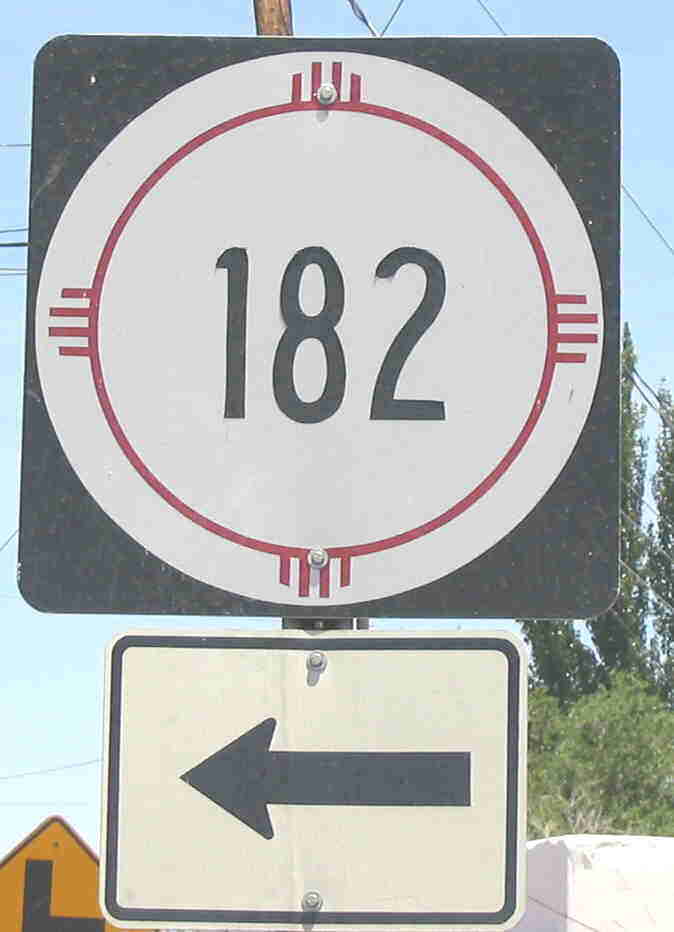
Photo taken at junction with NM-28 at La Union. Route marker appears much newer than the directional arrow.
East terminus: NM-28 E of La Union
Length: 2.033 mi.
County: Doña Ana
History: Apparently split off when NM-273 was rerouted in the late 1990s or early 2000s.
Comments: Not evident on any maps I've seen except that the 2003 NM state map shows the state highway through La Union ending south of that town. Otherwise, shown on Yahoo maps. I confirmed this in person, and NM-273 was definitely rerouted over former NM-319.
East terminus: Texas State Line near Vinton
Length: 0.598 mi
County: Doña Ana.
History: Likely established in 1988. Like NM-182, also originally part of NM-273.
Comments: Follows La Union-Vinton Road.

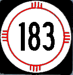
East terminus: NM-145 at Black Spring
Length: ~25 mi.
County: Catron
History: Established mid-1930s. After 1940 became part of the extension of NM-78 to U.S. 60, then removed from state highway system by 1988. Now NFS 30.
Comment: NM-184, 185, 186 and 187 are all shown only on a 1936 map and the official 1940 NM State map, with uncertain ends for these routes. Whether these were established as state highways, turned back and reestablished with their later designations I have no way of knowing.
East terminus: Texas State Line at El Paso
Length: 0.567 mi
County: Doña Ana.
History: A short connecting route to Country Club Drive in the Sunland Park area, probably established 1988. Originally designated as "NM-273 Stub." (Now, that's different --- what's the distinction between a Stub and a Spur?)
Improvements: Two-lane paved road
Comments:

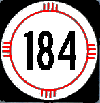
East terminus: NM-52
Length: ~30 mi.
County: Catron, Sierra
History: Established mid-1930s. After 1940 became NM-59, which it is today.
Comments: Another of the 184-187 routes shown on the 1936 map.
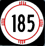
North terminus: NM-26 at Hatch
Length: 35.397 mi.
County: Doña Ana
History: Originally designated as U.S. 85 in 1927. In 1988, when U.S. 85 was eliminated as a marked route, this became NM-185.
Improvements: Two-lane, paved
Comments: U.S. 85 was a separate route from I-25 between Las Cruces and T or C, separated from the Interstate through much of this length by the Rio Grande. So, it was an important regional connector, even if not part of a major through interstate route. This segment of old 85 was broken up into two different routes, 185 and 187, separated by what was formerly a short common section with NM-26.

North terminus: NM-185 at Beaverhead
Length: 60 mi.
County: Grant, Catron
History: Established mid-1930s. After 1940, renumbered as an extension of NM-61. In 1970, the southern part became part of NM-35. By 1988, the northern part through the mountains became NFS 150.
Comments:

East terminus: Rio Grande Bridge
Length: 1.522 mi.
County: Doña Ana
History: Originally part of NM-404 since the 1970s, this segment was left in the state highway system after the portion of 404 between the Rio Grande and NM-460 was removed from the state highway system in the late 1990s. This segment received a new designation, consistent with the 180-series routes designated since 1988 in this area.
Improvements: Paved two lane
Comments:

North terminus: BL I-25 at T or C
Length: 36.253 mi.
County: Doña Ana, Sierra
History: Like NM-185, this was part of U.S. 85 from 1927 to 1988. It was given a different number because of the short common section at Hatch with NM-26.
Improvements: Paved two lane
Comments:

North terminus: U.S. 70 in Las Cruces
Length: 2.945 mi.
County: Doña Ana
History: Probably in the 1960s, established as a bypass for U.S. 85. (Actually signed "Truck Bypass," no number). In 1988, given a separate route number.
Improvements: Four lane
Comments: Although it is a straight-ahead extension of NM-185, it has a separate route number.

East terminus: NM-478 at Vado
Length: 1.2 mi.
County: Doña Ana
History: Probably established as a state highway in the late 1950s as part of NM-227. In 1988, because of a short common section with NM-478 in Vado, this part of 227 was given a separate designation.
Improvements: Two lane, paved.
Comments:

East terminus: Chaves County 1 E of Dexter
Length: 2.11 mi.
County: Chaves
History: Date of establishment not known, probably pre-1988 due to its number (otherwise it would probably be a 2xx route).
Improvements: Two lane, paved.
Comments: My Benchmark map shows NM-409 extending south from Bottomless Lakes and terminating near this road. However, no other map verifies 409 having been extended south, including the 2003 New Mexico highway map. So, I'm not currently of the opinion that 190 is a piece of old 409. It is too short to show on most maps and therefore could have been in existence for some time.
191

East terminus: NM-478 at Mesquite
Length: 2.367 mi.
County: Doña Ana
History: Probably established as a state highway in the late 1950s as part of NM-228. In 1988, because of a short common section with NM-478 in Mesquite, this part of 228 was given a separate designation.
Comments:
North terminus: U.S. 64-87 E of Raton
Previously --- Farley (early 1950s)
Length: 42.200 mi.
County: Colfax
History: Established early 1950s from old NM-58 (now U.S. 56) north to Farley only. Not shown as a marked route on several maps from the mid-1950s until the mid-1970s, when it is shown in its current length.
Improvements: Two-lane, paved except center section, which is gravel.
Comments: If it disappeared from the state highway system, it is unusual when compared with other routes that did this that it had the same designation when restored.
Previously --- U.S. 66 (BL I-40) in Albuquerque (1950s-1980s)
To: NM-528 in Alameda
Length 0.5 mi. (originally 8 mi.)
County: Bernalillo
History: Established along Rio Grande Blvd. in the early 1950s. By mid-1980s, only the portion in the city of Alameda remained. The route does not show on the Albuquerque detail map on the 2003 New Mexico highway map, and thus appears to have been removed from the state highway system in the early 2000s.
Improvements: Two-lane, paved
Comments:

North terminus: Claunch (?)
Length: ~ 25 mi.
County: Lincoln, Socorro
History: Only shows on a map I've seen from the early 1940s and the 1940 official NM map. Appears to have been an interim designation for a realignment of the southern end of original NM-15. The north end is uncertain because the map was not clear on exactly where it ended, but original NM-161 (which later became the south end of NM-41) intersected at Claunch. It may have reverted to NM-15 (the two routes are not shown in parallel at any time) and in any event, the road soon became the extension of NM-10, and is now part of NM-55.
Comments:
North terminus: NM-181 at I-25 exit 83 north of T or C
Length 6.555 mi.
County: Sierra
History: The western part of this route has been a state route since the 1920s, when it was part of U.S. 85. By the early 1940s, U.S. 85 was realigned to a more westerly route, and this became part of NM-52. Renumbered in 1988. The segment over Elephant Butte Dam became one-way eastbound at some point with westbound traffic having to take NM-51 and NM-177 to join this route east of the city of Elephant Butte. Although shown as part of the state highway, the route over Elephant Butte Dam was closed in 2001.
Improvements: Two-lane, paved
Comments: The routing over the dam is interesting because the top of this very old dam (constructed 1912-16) is barely wide enough for one vehicle. I don't know what traffic control was used to allow two-way traffic, but at some point the dam was made one-way eastbound with westbound traffic using NM-51 and (what is now) NM-177. The dam route is now closed.
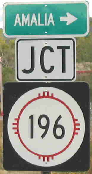
Photo taken at junction NM-522 in Costilla
East terminus: Ski Rio Ski Area
Previously --- Amalia
Length 11.659 mi.
County: Taos
History: Established 1940s, originally ran to the village of Amalia. In 1988, extended to the ski area.
Improvements: Two-lane, paved
Comments:

Previously --- village of Penistaja (1950s-60s)
East terminus: U.S. 550 at Cuba
Length 31.825 mi.
County: Sandoval
History: Established early 1950s, the west end of this road was originally at the village of Penistaja. In the 1960s, it was aligned more southerly to the village of Torreon. Today, it connects with BIA roads that cross the Navajo Reservation from Crownpoint.
Comments:

Photo taken at junction with NM-143 in March 2008
North terminus: NM-143 at Rockhound State Park
Length: 2.657 mi.
County: Luna
History: Established in 1988, along with NM-143, as part of a highway jurisdiction agreement with Luna County. Its northern terminus was originally NM-497, but the east end of that route was consolidated with NM-143.
Comments: Tracking this route has been confusing because it appeared to be an extension of NM-497 (now 143). It actually runs south off 143 about 1/2 mile before that route enters Rockhound State Park. This route connects to Spring Canyon State Park.

East terminus: U.S. 85 at Springer
Length 20 mi.
County: Colfax
History: Established by the mid-1930s. Combined with NM-21 in 1988, which designation it now bears.
Comments:

East terminus: U.S. 62-180 E of Carlsbad
Length 8.410 mi.
County: Eddy
History: Constructed late 1990s, became part of state highway system in 2000. Part of this route was formerly Eddy County Highway 604.
Comments: This is the Carlsbad Relief Route. Like the Santa Fe Relief Route, it probably received Federal funding to provide a bypass for trucks carrying nuclear waste from Los Alamos to the nuclear waste forever storage facility in salt beds east of Carlsbad.