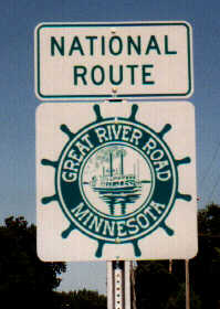
Great River Road Routing
Note: this is a generalized routing that does not include many short segments on local roads. Some of these are temporary segments pending construction of new roadway, such as the West River Parkway through downtown Minneapolis. Don’t rely on this list for a 100 percent complete routing.
|
Route |
Cities/Towns |
Comments |
|
Iowa Border (IA-26) |
|
|
|
MN-26 |
Brownsville |
|
|
MN-16 |
|
|
|
U.S. 61 |
La Crescent |
Includes short segment along I-90 Route may diverge at places along this stretch |
|
Goodhue and Dakota CSAH 18 |
|
|
|
Dakota CSAH 54/ 10th St. (Hastings) |
|
|
|
U.S. 61 |
Hastings |
Joined at Hastings by the Wisconsin leg that follows the east side of the river, and enters Minnesota via U.S. 10. |
|
Dakota CSAH 42 |
Hastings, Nininger |
|
|
MN-55 |
Pine Bend |
|
|
Dakota CSAH 56 (Concord Ave) |
Inver Grove Heights |
|
|
I-494 |
So. St. Paul/Newport |
Crosses Mississippi River at Wacouta Bridge |
|
U.S. 61/10 |
Newport |
|
|
Warner Road |
St. Paul |
|
|
Shepard Road |
St. Paul |
|
|
I-35E |
St. Paul/Lilydale |
Crossing Mississippi River (N-bound GRR on S-bound I-35E) |
|
MN-13 |
Lilydale/Mendota/ |
N-bound GRR on S-bound 13 |
|
MN-55 |
Mendota Heights/ Minneapolis |
|
|
Minnehaha Pkwy |
|
|
|
West River Pkwy |
Minneapolis |
Newly completed segment of West River Parkway between 4th Avenue South and Portland Avenue. Ends at Plymouth Ave |
|
Plymouth Ave, Marshall Ave, East River Road |
Minneapolis, Fridley |
Crosses river between West River Pkwy and Marshall Ave. |
|
I-694 |
Fridley, Brooklyn Center |
Crosses river between East River Road and MN-252. |
|
MN-252 |
Brooklyn Center |
|
|
West River Road |
Brooklyn Park |
|
|
Hennepin CSAH 12 |
Champlin |
|
|
Wright CSAH 39 |
|
|
|
Wright & Stearns CSAH 75 |
Monticello |
|
|
various St. Cloud city streets |
St. Cloud |
|
|
Stearns CSAH 1 |
|
|
|
Morrison CSAH ? |
|
|
|
MN-27 |
|
Crosses river into Little Falls. |
|
Little Falls city streets, Morrison CSAH 76 |
|
|
|
MN-371 |
|
|
|
MN-210 |
|
|
|
U.S. 169 |
|
|
|
Aitkin CSAH 3, CSAH 10 |
|
|
|
Itasca CSAH 3 |
Grand Rapids |
|
|
U.S. 2 |
Deer River |
|
|
Itasca CSAH 39, MN-46 Itasca & Cass CSAH 9 |
|
Loop from U.S. 2 north generally paralleling the river, returning along south shore of Lake Winnibigoshish. |
|
U.S. 2 |
Cass Lake |
Follows U.S. 2 for a long stretch. Crosses river at Lake Bemidji outlet entering Bemidji. |
|
NOTE: AT BEMIDJI, THE ROUTE DIVIDES. FOLLOWING IS THE SEGMENT THAT FOLLOWS THE MISSISSIPPI TO ITS SOURCE. THE ALTERNATE SEGMENT IS SHOWN BELOW ON A YELLOW BACKGROUND. | ||
|
Beltrami CSAH 7, 9 |
|
|
|
Clearwater CSAH 2 |
|
|
|
Note: the junction with County 2 and MN-200 is the entrance to Itasca State Park...the true head of the Mississippi River. Lake Itasca was named by its non-aboriginal discoverer, Henry Schoolcraft, who derived its name from the Latin for "true head", verITAS CAput. However, the GRR continues north into Canada. | ||
|
MN-200 |
|
|
|
MN-92 |
Bagley |
|
|
Clearwater CSAH 5 |
|
|
|
MN-89 |
|
|
|
MN-11 |
|
|
|
MN-313 |
|
|
|
Enter Canada and Province of Manitoba (MB-12) |
|
Route proceeds northwest toward Winnipeg |
|
** NORTH LEG from Bemidji via U.S. 71 |
Blackduck Northome Big Falls International Falls |
|
|
Enter Canada and Province of Ontario |
Ft. Frances. |
Route proceeds north to Kenora. |
Return to Main Minnesota Highways page
Created June 4 1998
Updated November 15 1998