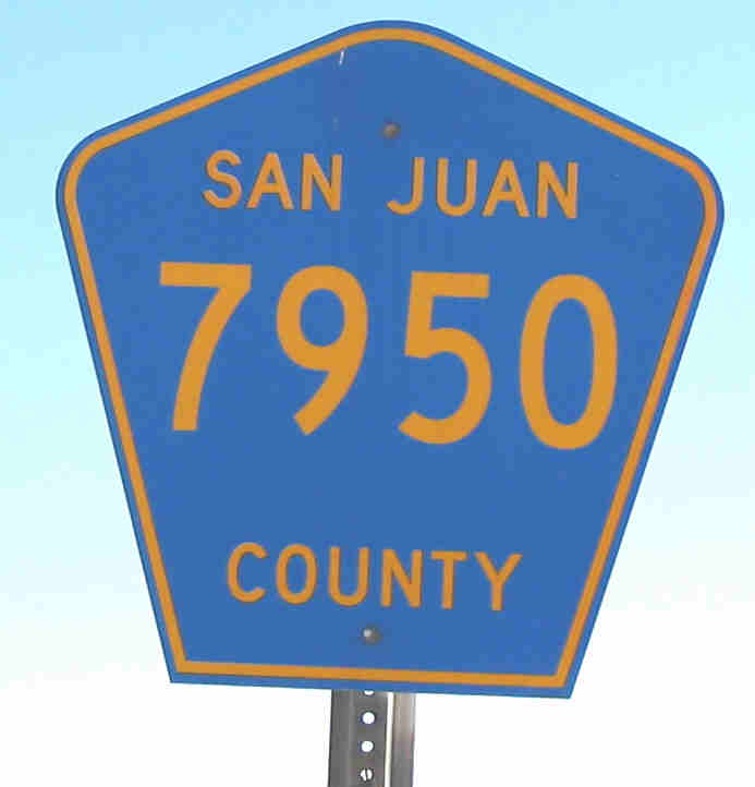
Road-Related Information for New Mexico
|
Quick jump to topics below: |
County Roads | Speed Limits |
| Highway construction standards | Relief Routes | Indian Routes |
Numbering of New
Mexico Highways.
New Mexico's first officially identified numbered route was the north-south
El Camino Real or Route 1, established by 1909, three years before
statehood. By the mid 1910s, official state maps show a statewide network
of numbered routes. It is not clear, though, whether these numbers were
merely an inventory for the state or whether the roads were actually signed in
some way. It is possible that the number was marked on directional signs,
but I have not seen a depiction of a freestanding route marker from this era,
nor have I seen any evidence of "pole markings" that were common in other states
during that time. A 1926 map indicates "No Official Marker" for New Mexico
state highways. Originally, the numbering system was a simple and sequential
bottom-up method, with principal through routes carrying the lowest numbers. It
should be noted that during this time there were a number of national named
motor trails that crossed the state, and it is reasonable to assume those routes
were marked with the appropriate markings for each route (either freestanding
signs or pole markings).
In 1927, the new U.S. highway system was
introduced, at which time state route numbers on the newly designated U.S.
routes were eliminated (and freed for reuse on other roads). At the same time,
an official route marker was introduced. Between establishment of the U.S.
route system and expansion of the highway network in New Mexico, there were
significant changes in the numbering system from the late 1920s into the early
1930s. The route lists accessible from the home page now show all routes, both
the pre- and post-1927 designations.
As you will see looking at the
route lists, there are still vestiges of the original pre-1927 system, and a few
routes still bear their original numbers from that era. The original system had
routes generally numbered under 121, and in fact when the first marked numbering
system was introduced all numbers were under 100 (though that only lasted for a
few years). But, as the state system grew, the number assignments were extended
higher. By the 1950s, the state began to take responsibility for shorter, local
roads. Numbers higher than 500 were assigned by 1960 (though there were never
that many roads actually in the system at any one time), and today they go over
600. There is no longer any correlation between the significance of a route and
whether it has a high or low number. While for the most part the current
numbering system can only be described as "random" within the range of assigned
numbers, there has been since 1988 a district-based numbering scheme that
results in clustering of newly-assigned route numbers. More on this topic
below.
There is no duplication of numbers between state and U.S. or Interstate routes. Back in the 1930s, state route numbers were changed if they duplicated a newly designated U.S. route. However, this was not done from the 1950s to about 1970, and during that time there were state highways numbered 10, 25 and 40 (the Interstates) as well as 56 and 82 (the newer U.S. routes) until about 1970. Even today, there is a NM-412, but U.S. 412, which does not exist in New Mexico independently, is not the official "inventory" number of U.S. 56-412.
In 1988, the state undertook a significant renumbering of the state route system. The "problem" this effort attempted to cure was that some routes followed complicated paths, connected with overlay sections on other state or U.S. routes. The solution was to establish a "no overlay" rule for state routes; any jog along another route, regardless of length, requires a new route to be established. This unfortunately broke up some routes that, though they had short overlays with other routes, were logical to maintain as continuous routes. Particularly hard hit were NM-44 (now restored as a continuous route as U.S. 550), NM-3 north of Las Vegas (519 and 522), NM-14 (337 and 55), and the state's longest route, NM-18 (209, 206, 402 and 406). The new routes established in 1988, when they were not designated as extensions of other state routes, were often numbered with three-digit numbers where the first digit is the NMDOT district number. This also explains why routes with numbers over 600 were established in western New Mexico (District 6), even though there are quite a few unused numbers under 600.
Speed Limits. The only statutory speed limits in New Mexico are 30 mph in business and residential zones, and 75 mph on other highways. The state may establish lower or higher limits based on design speed or a speed study. The following table lists typical speed limits for various classes of roads.
| Interstate Highways-rural |
75 mph |
There are a few non-urban segments marked slower. Both I-25 and I-40 have 70 mph zones approaching Albuquerque from the east and north, and I-10 is marked 70 mph from Las Cruces to the Texas border to match the speed limit in Texas. |
| Interstate Highways -urban |
65 mph |
The interstate highways through Albuquerque are both posted 65 mph. It's hard to picture Gallup as urban, but I-40 is posted 65 mph around that city as well due to the presence of several relatively closely spaced exits. Both I-10 and I-25 are marked 65 mph around Las Cruces, as is I-10 around Deming. However, I-25 around Santa Fe, due to the paucity of interchanges, is posted 75 mph. There are a couple of very short 55 mph stretches along I-25 due to localized conditions. |
| Divided Highways -rural |
65- |
Divided highways are generally posted 65 mph, but on the wide open spaces of the eastern plains, there are 70 mph segments such as U.S. 285 south of Vaughn and U.S. 70 east of Roswell. More recently upgraded highways such as U.S. 550 and U.S. 64-87 also have 70 mph sections. U.S. 70 across the White Sands Missile Range is posted 75 mph, probably because the restricted nature of the surrounding area greatly limits side road traffic. |
| Two-lane roads |
55- |
It's difficult to determine the rationale for how the state posts two lane roads. Highways that have wide paved shoulders and limited side road traffic are generally posted 65 mph. Roads with narrower shoulders with limited intersecting roads are often posted 60 mph, and roads that do not have paved shoulders are usually 55 mph. There seems to be exceptions in both directions that are not easily explained by site-specific road conditions, however. In general, New Mexico is much more conservative than neighboring states (Arizona and Colorado) in applying 65 mph speed limits to two lane roads. |
| Business and Residential Roads |
30 mph |
Cities appear to have the ability to set lower limits on residential or business streets, since 25 mph zones are not uncommon (but are posted). |
Highway construction standards. The only non-interstate highway freeway segments in the state are U.S. 70 for about 10 miles east of Las Cruces and a 13-mile segment of U.S. 84-285 north of Santa Fe. Otherwise, the only true freeways in New Mexico were the three Interstate highways that cross the state. There are no 3-digit interstates. Otherwise, New Mexico does have quite a few miles of four-lane divided highway along its major routes (U.S. 285 from I-40 south to Carlsbad, U.S. 550 from Aztec to Bernalillo, U.S. 70 from Las Cruces to Alamogordo, and many other shorter segments). Some of these roads are actually four lanes with a double-double line median. Future projects will extend the divided segments of U.S. 64-87 from Raton to Clayton and widen U.S. 491 from Gallup to Shiprock. By comparison, in 1926 the only paved highways in the state were from Albuquerque halfway to Santa Fe and from Las Cruces to the Texas border.
Relief routes. New Mexico has several roads with this unique designation --- unique because I haven't seen it used elsewhere in the country. As fancy as it sounds, a Relief Route is simply an urban bypass. They exist (at least that I've seen) at Santa Fe (NM-599, between I-25 south of the city and U.S. 84-285 northwest of the city); Alamogordo (officially U.S. 54-70 running west of the city); Carlsbad (NM-200), between U.S. 285 northwest of the city and U.S. 62-180 east of the city; and Roswell (still marked Truck U.S. 70-285 as of 2007, but all official information indicates that it is the U.S. 70-285 mainline, running west of the city).
Route markings. State roads were first marked with a uniform marker in 1927, when the U.S. routes were assigned and marked. Before that, route numbers were assigned, but the 1926 Rand McNally atlas indicates that no official marker was used. It is possible that "pole markings" (painted markings on telephone poles) were utilized. New Mexico has always used the zia --- the Indian sun symbol that is found on the state flag --- as the main element in its route markers. Depictions of the route marker designs used by New Mexico are shown below.
The current sign design has been used, with only minor variations, since some time in the 1960s (it was in almost exclusive use when I moved there in 1971). It has the number inside a red zia on a circular white background, surrounded by a black square. Occasionally, you see a sign without the zia, looking much like an Iowa route marker. A few of these when used for 3-digit routes are elliptical. The red paint used for the zia tends to fade, so some signs look like they were made without the zia when in fact they are weathered. Guide signs always use a plain circle (no zia) for state route markers, and newer interstate guide signs use an ellipse for 3-digit routes. Older interstate guide signs use circles for 3-digit routes.
U.S. routes are generally not marked where
they are concurrent with an interstate. The exception seems to be U.S.
60 along I-25 --- but it's mostly marked north/south like I-25, not east/west
like the rest of U.S. 60.
I have been looking for information on the
history of the New Mexico route marker. While I don't have specific years that
shield design changed, I have found examples of the various designs used over
the years since they were first posted in 1927, and been able to construct the
following history. I reviewed numerous photos on the web site Shield
Gallery on AA Roads, maintained by Levante ("Jake") Jakab. Bring a sandwich,
you'll spend lots of time there.
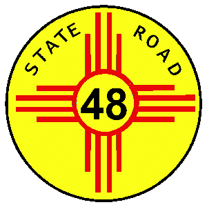 |
Depictions on maps from the late 1920s and early
1930s showed a zia with a small circle. This was confirmed thanks
to information from Bill Johnston, who provided an actual
photo of an early
sign . This shows that the circle of the zia
was much smaller than in later signs. (Made it a little difficult to
render 3-digit routes.) I believe this style was probably
only used until no later than the mid-1930s, because with more 3-digit
routes coming into existence New Mexico had to find a design that provided
more visibility for the number. This number was printed, not
embossed, and at that time there were no reflective background sign
materials available. The zia and "STATE ROAD" legend were
embossed. |
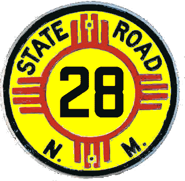 |
The revised design widened the circle in the zia and added the state abbreviation N.M. across the bottom of the sign. Unfortunately, there are no examples of 3-digit signs on Shield Gallery, but the yellow signs uniformly appear to have been embossed with the number. Reflectivity was provided by "button copy"; that is, tiny glass reflectors on the number. I didn't attempt to depict the reflectors on my replica here. As noted above, my guess as to when these signs began being used is no later than mid-1930s. There were some NM-2 shields in this design shown on Shield Gallery, and the original manifestation of that route was eliminated about 1935. |
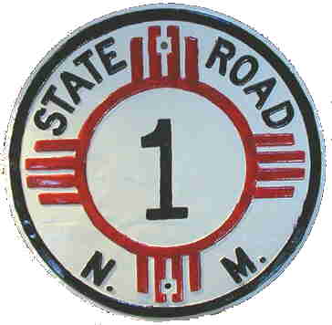 |
This style of route marker, a modification of the original yellow marker, probably was introduced by the early 1950s. This sign was restored by Mike Wade of Artesia, NM, who kindly offered the photo for my use here. The lettering and zia were still embossed, but the number was not. My guess is that, by the early 1950s, reflectorized sign materials like Scotchlite made this the preferred way to make signs visible at night, and with the necessarily white background behind the number, the rest of the sign was made white as well. It is therefore not possible to know what route this was originally posted on. Another possible factor is that numbers higher than the 100s (reached by the late 1940s) required more width and weren't practical to emboss, so the transition to a printed sign was made. |
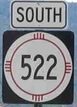 |
This is a current and very typical NM route marker,
essentially what was common when I moved to the state in 1971 (except
signs were made of wood then and are now all metal). As you will observe
as you tour my route listing pages, where I have photos of a number of
individual route markers, the width of the zia and the height of the
numbers vary greatly. A problem with these signs is that red tends to fade
faster in the intense New Mexico sunlight than other colors, and often an
older sign looks like an Iowa-style circle on square when in fact it
originally looked like this. There are a few markers around that are
circle-on-square or ellipse on rectangle, but they are generally at
freeway interchanges and thus may have been manufactured by
contractors. |
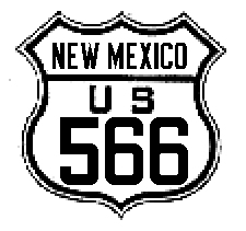 |
The original U.S. route markers were completely embossed, number and all. Probably through the 1930s, reflectivity was accomplished using button copy - glass reflectors glued to the numbers. Later, in a transitional design, the state name and US were embossed but the number imprinted on a Scotchlite background. This probably was used through the early 1950s. |
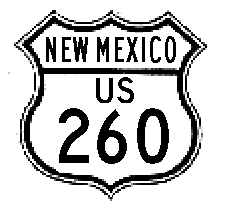 |
By the early to mid-1950s, the U.S. route markers
were completely imprinted on the sign, with the number on a reflectorized
(Scotchlite) background. The font changed from the blocky, embossed
font typical of early route markers in the U.S. to a font similar to FHwA
standard font used today. |
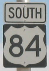 |
The standard, white on black, non-cutout type of U.S. marker appears to have become standard by the early to mid-1960s. There may have been a brief transitional design that had the legend "U.S." over the number on a sign like that at left, but it was probably not in common usage. The only major modifications in design since this time have been variations on the number size, and a move to use rectangular signage for all 3-digit U.S. routes - even those beginning with "1" that don't necessarily need the additional room. In the 1970s, all numbers were displayed on square signs. |
Return to New Mexico Highways Home Page
Updated May 28, 2010