Jump to route markings
How Minnesota Highway Route Numbers are Assigned
Until around 1934, when a large number of new legislative routes were added, trunk highways were virtually always numbered the same as their constitutional or legislative route numbers. In general, with the Constitutional Routes, lower numbered highways were the more primary routes. Since that time, there is no real pattern or hard and fast rule to numbering Minnesota routes. Generally, the designation is based on one of the following criteria:
- It may be designated the same as its L.R. number, or the L.R. number of one segment of a trunk highway with several legislative route numbers;
- It may have an arbitrarily assigned number, usually less than 125;
- It may be numbered based on association with another highway (although 3-digit numbers generally do not indicate such an association).
Note that I don't list "clustering" as a criterion for numbering. Actually, there is some clustering of the legislative route numbers, which occured as groups of highways were authorized at the same time, and thus nearby routes received adjacent legislative route numbers. In this instance, geographically close highways might be numbered in a cluster if their legislative and trunk highway numbers are the same. Between the "arbitrary" route numbers and routes that match their legislative/constitutional route numbers, all numbers 124 and less have been used at least once. Numbers used for U.S. or interstate routes are not reused arbitrarily as state numbered routes elsewhere. However, several state-numbered routes are extensions of a U.S.-numbered route (61, 65, 169, and formerly 212), even though only one of these current state routes (169) touches its parent U.S. route. This latter convention doesn't really violate the no-duplication rule. There is one numbering quirk: by taking this link to explore MN-62, you can find out why there are two routes so numbered .
It should be noted that MnDOT hates to duplex U.S. with Interstate routes. U.S. 52, which is duplexed with I-94 for 230 miles from North Dakota to St. Paul, is not marked at all along the route (with the possible exception of a few old guide signs that have not yet been revised). Even U.S. 12, which is duplexed with I-94 for 25 miles between Minneapolis and Wisconsin, is not marked either. Typical of the marking used to indicate the co-numbered segment is a sign on U.S. 52 just prior to joining I-94 that reads, "(U.S. 52) Follow (I-94) West." That's the last you see of 52 until entering North Dakota. U.S. 61, which used to be duplexed for 120 miles with I-35 between Wyoming and Duluth, was decommissioned, and north of Duluth was redesignated MN-61 to the Canadian border.
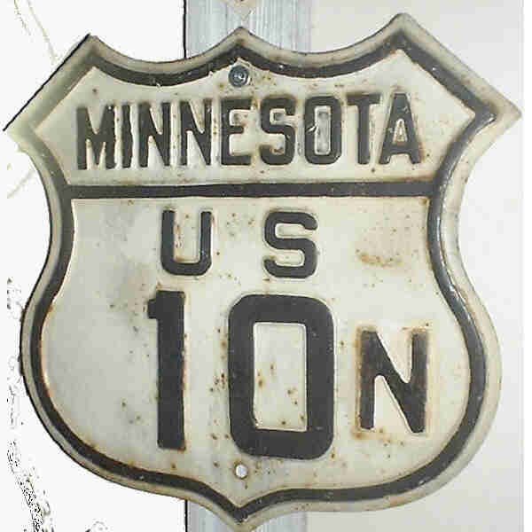
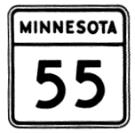
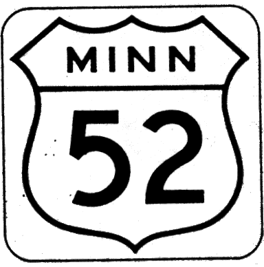
Major renumberings. The all-time major renumbering occurred in 1934, when around 140 new legislative routes were added at one time. This major addition of routes necessitated a revamping of the numbering system, and the resulting network looked much like today's. At the same time, there was a change in U.S. highways. U.S. 55, 10S and 10N were eliminated, and U.S. 52 introduced. Shortly thereafter, in 1935, U.S. 63, 69 and 59 were added to the system, which necessitated changing of state trunk highways with those numbers. The 1934 map shows changes that disappeared a year later, particularly in the length of newly extended U.S. routes (65, 212, 218). According to old Department of Highways documents, the markings shown on the 1934 map were indeed posted that year, and then updated in 1935 to reflect the approved U.S. route numberings. (My unsubstantiated guess is that Minnesota jumped the gun on AASHO approval of the numberings and had to back off the next year). A significant renumbering around 1963 consolidated and broke up route continuity along quite a few routes as well.
Business routes. There are currently two trunk highways marked as the business route of another trunk highway: U.S. 2 Business through East Grand Forks, and MN-371 Business through Brainerd. However, there are other business routes in Minnesota, most of which are under local or county control. There are business loops of I-94 at Moorhead (old MN-231, but now a city street); I-90 at Fairmont and Austin (on county and city roads, respectively); and I-35 (following U.S. 65) at Albert Lea. There is also a business route on and MN-23/U.S. 71 at Willmar (a city street). This latter route is interesting for the signs used: apparently made by MnDOT, they are a green cutout U.S. shield for Business 71 and a green square for Business 23 (both read "Business xx"). A more common convention is to maintain a county route through a city on the former trunk highway route and mark it with its county route number and the supplemental legend "Thru City." A good example of this is the route marked from U.S. 10 at Little Falls. The only trunk highway marked this way is MN-197, old U.S. 2/71 through Bemidji, which is marked "MN-197 Thru City."
Route Markers --- Past and Present
There have been three general "eras" of route markers since the 1920s, as illustrated below:
 |
The original state route marker design used after 1920 was a yellow star in a black circle, on a square yellow background. These markers were originally stenciled on telephone poles and later put on signs. This is a photograph of a sign in the collection of Robert Edgar of Bakersfield, CA. When found, it had a white background like the sign depicted below, but yellow paint underneath. Thus, it may have originally been posted along the original Trunk Highway 7 --- also U.S. 14 --- and then repainted and moved to the new T.H. 7 established in 1934. Robert did an excellent job restoring the sign to its original colors. |

|
In the major route renumbering of 1934, the former yellow markers were replaced with white background markers. This design was used until around 1954. Texas is the only other state to have used a star design, and no North American entity uses this primary design feature today. A possible reason for a design change was that this design did not display three-digit numbers adequately.
U.S. routes originally were the traditional cutout, Minnesota/U.S. xx signage. These were gradually replaced by the 1950s by other, transitory styles that abandoned the cutout style and used either "U.S." or "MINN" over the top line. Some "MINNESOTA/U.S. " signs on a black background were also used and were seen on the road into the 1980s. This sign from the collection of Robert Edgar (Bakersfield CA).
|
|
The next design introduced in the mid-1950s, and used until the late 1960s, was similar to today's Maryland route markers: all white background, with the legend MINNESOTA in the top one-fourth , and separated from the number portion of the sign by a line. Effective at displaying all numbers, but as bland as Swedish cooking.
U.S. signs went through several alternative, non-cutout designs; I've chosen the one used on state maps of the era. It may not be clear, but the U.S. shield is on a white, square background. Other designs used had "U.S." over the line or "Minnesota/U.S. xx" on either a white or black background.
|

|
Around 1968, the current state marker design was introduced. It is distinctive among state route markers for several reasons. First, it is the only sign in the U.S. that uses a blue background. (Several Canadian provinces use blue-background route markers on some of their routes.) Second, like Tennessee's, it has the state outline as a secondary, rather than as the primary design element. Finally, it uses three colors (blue, yellow and white) --- though when first introduced, the signs had yellow numbers, and a few of these signs still exist. That shade of yellow varies somewhat --- sometimes it's the shade of Gulden's Mustard, sometimes it's reddish. I think it's supposed to be gold. Virtually all three-digit reassurance marker signs are square, using a compressed font if necessary, but on guide signs rectangular three-digit signs with standard width FHwA font are standard.
The only U.S. marker used today is the standard U.S. shield on black background, with no text. Lacking a photo or a scanned image with a Minnesota U.S. route number in it, I am using one of the graphics created for my route listings as illustration. A California cutout style with only "U S" over the number was formerly used on freeways in conjunction with Interstate markings, but now in the rare instances U.S. routes are marked on interstates, the standard design is used.
|
Scanned images above courtesy of Ron Wilbanks.
Return to Minnesota Highways Home Page.
| Originally uploaded December 19, 1997 |
Last updated January 12, 2003 |